
Geodetic datum
Geodetic datum is fundamental land information under the Land Information Authority Regulations 2007 (Land Information Authority Act 2006) and consists of geodetic survey marks known as Standard Survey Marks, referenced to the Geocentric Datum of Australia 2020 (GDA2020).
GDA2020 is the primary horizontal datum and the only datum being maintained by Landgate. GDA94 is considered a historic datum.
GDA2020 consists of all Landgate’s survey archive data (revised and rescaled as required), as well as the most recent surveys. GDA2020 is free of many of the biases and distortions associated with GDA94 and aligns better to the global reference frame, in which GNSS operate.
GDA2020 is a product of a single national network adjustment, with rigorous error propagation from Continuously Operating Reference Stations (CORS). GDA2020 was gazetted on 11 October 2017, by the National Measurement Institute, as the Recognized-Value Standard of Measurement of Position as per the Determination 2017. For more information about GDA2020 refer to the ICSM website.
Datum transformation
Coordinate transformation is the process of changing coordinates from one datum (reference frame) to another. There are three options for the transformation of coordinates between GDA94 and GDA2020:
- 2D conformal NTv2 grid file [EPSG: 8446]
- 2D conformal + distortion NTv2 grid file [EPSG: 8447]
- 3D 7-parameter similarity (Helmert) transformation (conformal) [EPSG: 8048].
There are additional 2D conformal only transformation grids for the Indian Ocean Territories:
- Christmas Island [EPSG: 8444]
- Cocos (Keeling) Island [EPSG: 8445].
NOTE: There are no conformal + distortion NTv2 grids available for the Indian Ocean Territories. The figure below shows the extent of the NTv2 national conformal + distortion transformation grid.

The following facts should be considered before selection of a GDA94 toGDA2020 transformation method:
- If local geodetic network control marks (SSMs) were used for referencing and/or establishing GDA94 coordinates, localised distortion will need to be taken into account. In this case, the conformal + distortion grid should be used to transform the GDA94 coordinates to GDA2020.
- If GDA94 coordinates were observed using Global Navigation Satellite System (GNSS) technology, with corrections coming from a network of GNSS reference stations (CORS), it is likely that the coordinates will be unaffected by local distortions. In this case, the conformal grid or a seven-parameter similarity transformation would be most suitable to transform the GDA94 coordinates to GDA2020.
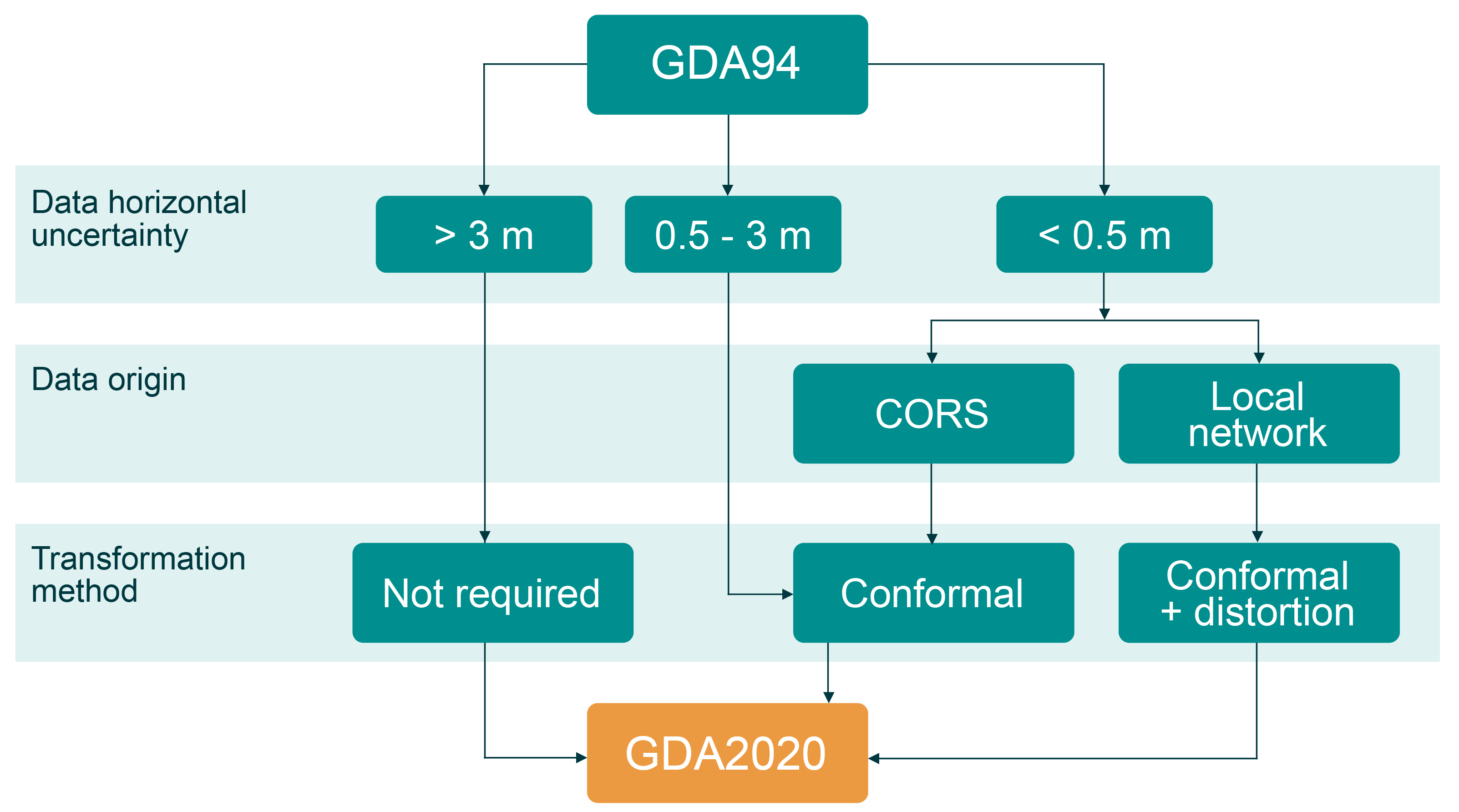
Unless the benefits of adopting another transformation method [EPSG: 8446 or 8048] have been expressly identified, the conformal + distortion NTv2 transformation grid [EPSG: 8447] is the recommended transformation method for spatial data in Western Australia. Use the 7-parameter similarity transformation method or NTv2 conformal only grids to transform data outside the extent of conformal + distortion grid.
For GDA94 to GDA2020 transformation products, tools, and manual refer to the ICSM website and the Coordinate Transformation section of the GDA2020 Technical Manual. To test transformation results we recommend GDAy 3.0 developed by ICSM or Geoscience Australia GDA94 - GDA2020 Online Transformation Service. This service provides a reference standard to enables software developers and spatial professionals to transform their data.
Comparing the transformed GDA2020 coordinates to the GOLA published GDA2020 coordinates of an SSM is not a valid check for transformation calculations. SSM coordinates have been determined by a rigorous network adjustment. All transformation methods have a degree of uncertainty. Thus, when comparing SSM transformed GDA94 coordinates to the published GDA2020 coordinates, small differences attributed to the transformation errors are expected. Additionally, as Landgate maintains and improves GDA2020 datum by introducing new measurements and resolving outliers, derived GDA2020 coordinates of SSMs are subject to ongoing revisions. This will slowly degrade the performance of the conformal + distortion grid.
Datum transformation should not affect orthometric height (AHD).
Web-mapping applications
Current web-mapping services use WGS84 Web Mercator (WGS84WM) Coordinate Reference System (CRS - datum and projection), registered under EPSG: 3857. WGS84 has been popularised as a de-facto web-mapping standard by commercial providers and many online maps default to this CRS. WGS84 is not the Australian Recognized-Value Standard of Measurement of Position, as determined by the National Measurement Institute, and it is not prescribed in our legislation. In addition, WGS84 is a time dependent datum (not static), and the Web Mercator is not a conformal projection. Using WGS84WM can yield significant data misalignment and distortion. The dynamic nature of WGS84 means that it coincided with GDA94 in 1994 and again with GDA2020 in 2020. This creates a well know issue for the web-mapping environment where GDA94 and GDA2020 data are misaligned when using null transformations [EPSG: 1150 and 8450].
For additional information related to WGS84WM issue please refer to this ICSM report.
Metadata
GDA2020 differs by only 1.8 m from GDA94, which is why it is extremely important to provide the datum name and, if applicable, transformation method in the metadata. Refer to the ICSM metadata document for implementation details and examples.
Australian Terrestrial Reference Frame 2014 (ATRF2014)
Like GDA94, GDA2020 is fixed to the Australian continent, where coordinates do not change with time. GDA2020 is a static reference frame (static datum). However, on 1 January 2020 ICSM introduced a time dependent reference frame called Australian Terrestrial Reference Frame (ATRF). Coordinates in ATRF will change over time as the Australian continent drifts and due to local deformation. ATRF is a time dependent reference frame (dynamic datum). The first realisation of ATRF is called ATRF2014. For more information refer to the ICSM website and ATRF technical implementation plan.
Both ATRF2014 and GDA2020 will be supported. GDA2020 is available for users who do not need a time-dependent reference frame. ATRF is optional and only for users who do need a time dependent reference frame. GDA2020 and ATRF are compatible and support different user requirements. The Australian Plate Motion Model can be used to propagate coordinates between GDA2020 and ATRF2014.